
Q-NFM
Quantifying the likely magnitude of nature-based flood mitigation effects across large catchments
1st Nov 2017 to 31st Mar 2023
The 2007 floods prompted the UK Government's "Pitt review", which came up with the idea that we need to start to deal with the causes of flooding upstream of the affected communities, rather than rely solely on engineering solutions at the community. This stimulated a range of organisations to introduce "natural" features into the landscape that may have benefits in terms of reducing flood peaks and so flood risk (so called "Natural Flood Management, NFM"). Having introduced features these organisations, and local stakeholders working with them, were asking "Are these features working?" This has highlighted to funders, those implementing the features and scientists alike that there are gaps in the evidence of how individual features (e.g. a single farm pond or a small area of tree planting) or whole NFM schemes work and what are potential the benefits for communities at risk of flooding. Stakeholders want both questions answered at the same time, making this one of the most important academic challenges for hydrological scientists in recent years. The only way to quantify the effects of many individual features at larger scales of catchments perhaps 100 sq km is to use computer models. To be credible, these models also need to produce believable results at individual feature scales. Meeting this challenge has been the focus of this research project. Consequently, our primary objective is to quantify the likely effectiveness of these NFM features for mitigating flood risk from small catchments (1 sq km) to large catchment scales (100 to >1,000 sq km) in the most credible way.
In this context, credibility means being transparent and rigorous in the way that we deal with what we do know and what we don't know when addressing this problem using models. In doing this we have needed to address particular scientific challenges in the following ways:
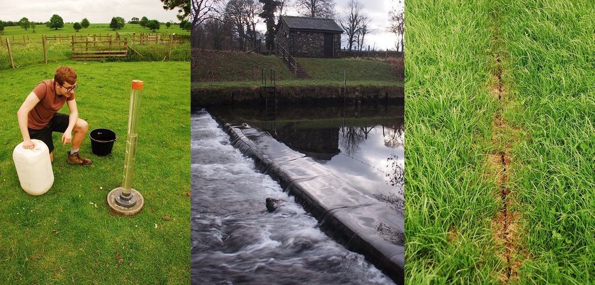
- We have needed to show that our models are capable of reproducing downstream floods while at the same time matching observed local hydrological phenomena, such as patterns of soil saturation. Integral to our methodology are direct observations of these local phenomena to further strengthen the credibility of the modelling
- We use the same models to predict NFM effects by changing key model components. These changes to the components are made in a rigorous way, initially based upon the current evidence
- As evidence of change is so critical, our project has necessarily included targeted experimental work to address some of the serious evidence gaps, to significantly improve the confidence in the model results
- This rigorous strategy provided us with a platform for quantifying the magnitude of benefit that can be offered by different spatial extents of NFM implementation across large areas.
By addressing these scientific goals we believe that we have delivered a step change in the confidence of our quantification of the likely effectiveness of NFM measure for mitigating flood risk from small catchment to large catchment scales.
Funding sources
Natural Environment Research Council (EAA7563, EA7861 and EAA7563XS01)
Investigators
Nick A Chappell (PI), Keith Beven (CoI), John Quinton (CoI), Phil Haygarth (CoI), Trev Page (PDRA1), Peter Metcalfe and Ann Kretzaschmar (PDRA2), Gareth McShane and David Mindham (Field Technician), David Johnson (Rivers Trust subcontractor), Barry Hankin, Researcher Co-investigator 0.5FTE (JBA subcontractor)
Project partners have included
Listed alphabetically: Brackenburgh Estate, Cheshire Wildlife Trust, Cumbria County Council, Cumbria Wildlife Trust, Eden Rivers Trust, Environment Agency, Forestry Commission England, JBA Trust, Lowther Estate, National Farmers Union, Rivers Agency (NI), RSPB, South Cumbria Rivers Trust, United Utilities, West Cumbria Rivers Trust, Woodland Trust & Yorkshire Dales National Park