R2 version 4.11 September 2023
R2 is a forward/inverse solution for 3d or 2d current flow in a quadrilateral or triangular mesh.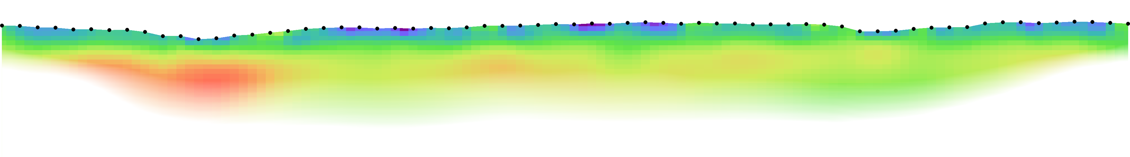 The inverse solution is based on a regularised objective function combined with weighted least squares (an Occams type solution) as defined in Binley and Slater (2020) (see also, Binley and Kemna, 2005; Binley, 2015).Electrodes can be placed on the ground surface or in boreholes. Topography is easily accounted for in the finite element mesh. A 32bit and 64bit version for Intel compatible processors are provided in the download. Executables for other platforms are available from the author.
The current (64 bit) version has no problem size limits.
The inverse solution is based on a regularised objective function combined with weighted least squares (an Occams type solution) as defined in Binley and Slater (2020) (see also, Binley and Kemna, 2005; Binley, 2015).Electrodes can be placed on the ground surface or in boreholes. Topography is easily accounted for in the finite element mesh. A 32bit and 64bit version for Intel compatible processors are provided in the download. Executables for other platforms are available from the author.
The current (64 bit) version has no problem size limits.
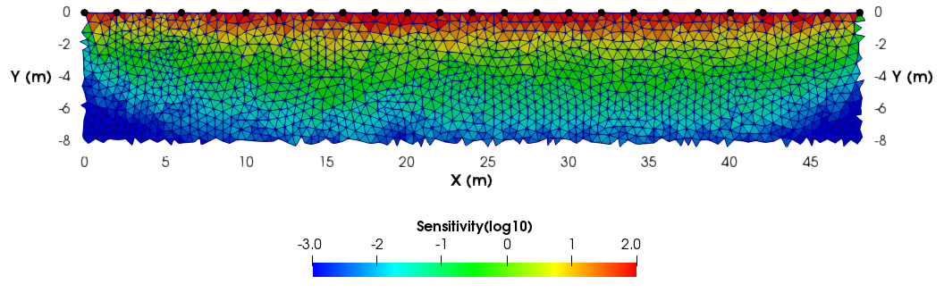 R2 will allow time-lapse inversion of resistivity data and also contains features allowing regularisation disconnect and zoning within the region of investigation. If requested by the user, in inverse mode R2 will output a resolution matrix or sensitivity map.
R2 will output inverse models in x,y,z ASCII format suitable for plotting with third party software. R2 also produces vtk formatted output allowing quick plotting with Paraview
Changes to R2 from v4.10
Minor bug fixes.Changes to R2 from v4.02
Sensitivity map now also output in scaled form. Some additions to the documentation.Changes to R2 from v4.01
If the starting model satisfies the data then output is generated (previously the files were left empty). Bug fix related to calculation of memory estimation during execution.Changes to R2 from v4.0
The calculation of resolution matrix has been improved. Checks for vtk output of negative values of resolution matrix made. Minor edits to output and documentation.Changes from R2 v3.3
General quadrilateral mesh input now an option. Specification of dirichlet node in mesh.dat changed. Some bug fixes and input file error checking.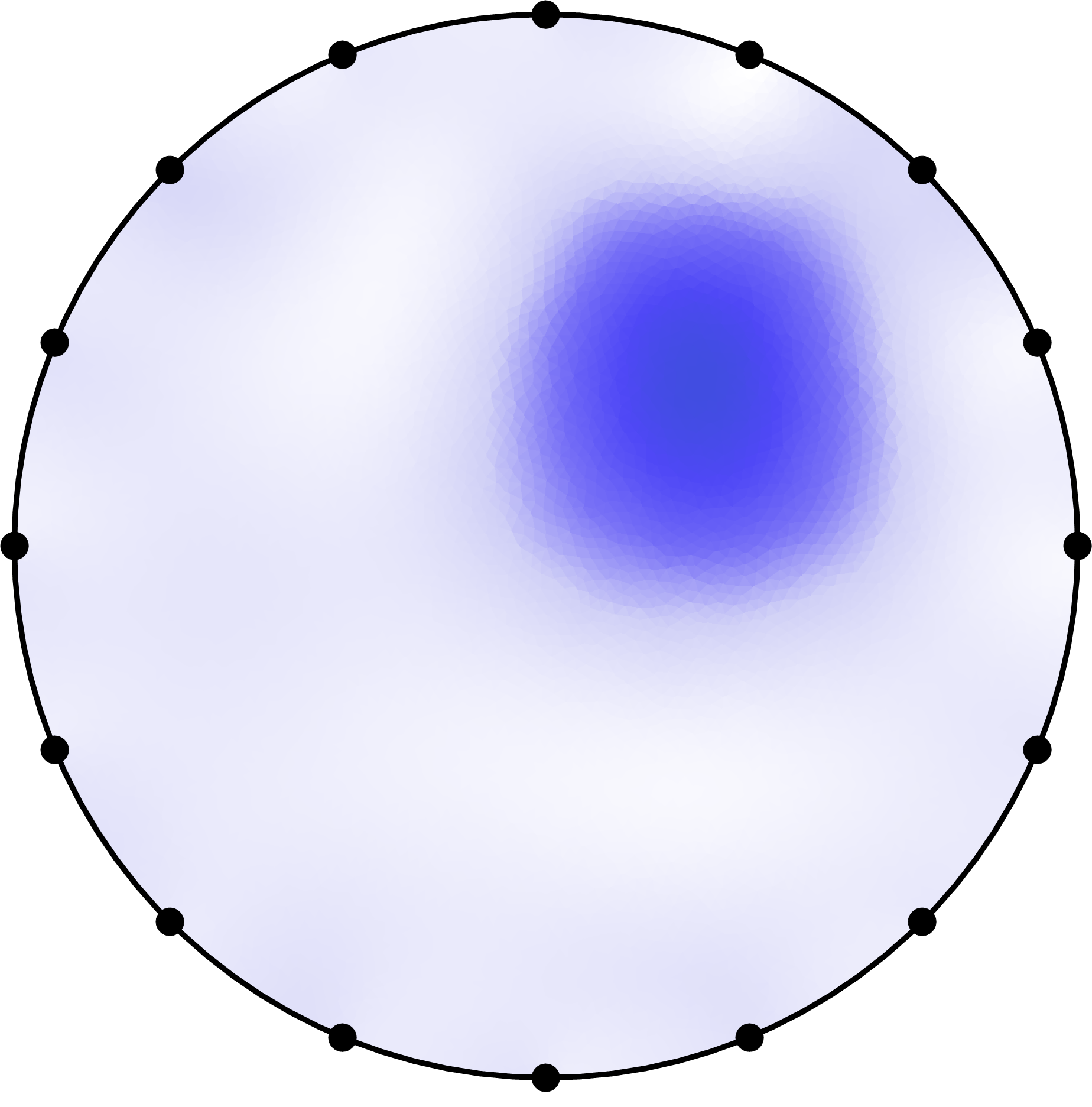
Changes from R2 v3.2
Minor bug fixesChanges from R2 v3.1
In a difference inversion the vtk output file now contains the percentage differences. Error checks on input of the data file (protocol.dat) are now made (to avoid incorrect electrode numbering). Output of a vtk file containing inversion results at each iteration is now included (previously this was only output to a .dat file). Some utility codes have been added to help with creating triangular meshes. A bug fix when using a triangular mesh has been fixed. Third party codes and scripts have been added. Documentation has been improved by adding more illustration of meshing and parameterisation.Download R2
Note that there is no installation script to run. The R2 executable should be copied to a working folder and run from there. Examples are provided (see download below).User guide (pdf)
Download R2 program and guide ( .zip file)
pyres: Python wrapper for R2
Kevin Befus has written a useful Python wrapper for R2. Details can be found in:Befus, K. M. (2018), pyres: a Python wrapper for electrical resistivity modeling with R2, J. Geophys. Eng., 15(2), 338-346, doi:10.1088/1742-2140/aa93ad.
And on GitHub

ResIPy: Python GUI for R2 (and sister codes)
Guillaume Blanchy (formerly Lancaster, now Liège), Sina Saneiyan (formely Rutgers, now Oklahoma) and Jimmy Boyd (Lancaster) have developed ResIPy: a python GUI for R2 and sister codes. The GUI is open source and standalone executables are available at the ResIPy gitlab site. Video tutorials for ResIPy are available at ResIPy videos. See also Blanchy et al.(2020).Example applications of R2 (send more to A Binley)
A numerical exploration of hyporheic zone solute transport behavior estimated from electrical resistivity inversions by Zhang et al.(2023)Unravelling soil water dynamics in almond orchards characterized by soil-heterogeneity using electrical resistivity tomography by Vanella et al.(2022)
Imaging the distribution of bitumen contaminants in shallow coastal plain sands in southwestern Nigeria using electrical resistivity by Jekayinfa et al.(2023)
The Ibadan Hydrogeophysics Research Site (IHRS) An Observatory for Studying Hydrological Heterogeneities in A Crystalline Basement Aquifer in Southwestern Nigeria by Doro et al.(2023)
Hydrogeophysical Inversion of Time-Lapse ERT Data to Determine Hillslope Subsurface Hydraulic Properties by Pleasants et al.(2022)
ERT Feasibility Study to Assess Unknown Bridge Foundation Depth by Cardoso and Lopes (2022)
True 2-D Resistivity Imaging from Vertical Electrical Soundings to Support More Sustainable Rural Water Supply Borehole Siting in Malawi by Leborgne et al.(2021)
Hydrogeophysical comparison of hillslope critical zone architecture for different geologic substrates by Parsekian et al.(2021)
Reservoir prescriptive management combining electric resistivity tomography and machine learning by DellAversana(2021)
Seasonal shifts in surface water-groundwater connections in a ferricrete-impacted stream estimated from electrical resistivity by Rickel at el.(2021)
Parameterization of a hydrologic model with geophysical data to simulate observed subsurface return flow paths by Claes et al.(2019)
The Effect of Hurricane Irma Storm Surge on the Freshwater Lens in Big Pine Key, Florida using Electrical Resistivity Tomography by Kiflai et al.(2019)
Solute Transport and Transformation in an Intermittent, Headwater Mountain Stream with Diurnal Discharge Fluctuations by Ward et al.(2019)
Form-based river restoration decreases wetland hyporheic exchange: Lessons learned from the Upper Colorado River by Sparacino et al.(2019)
ERT and salinity - A method to determine whether ERT-detected preferential pathways in brackish water-irrigated soils are water-induced or an artifact of salinity by Brindt et al.(2019)
Groundwater resources evaluation in calcareous limestone using geoelectrical and VLF-EM surveys (El Salloum Basin, Egypt) by Zarif et al.(2018)
Methods to estimate changes in soil water for phenotyping root activity in the field by Whalley et al.(2017)
Electrical resistivity imaging for long-term autonomous monitoring of hydrocarbon degradation: Lessons from the Deepwater Horizon oil spill by Heenan et al.(2017)
Scenario Evaluator for Electrical Resistivity (SEER) Survey Pre-Modeling Tool by Terry et al.(2017)
Comparing Measurement Response and Inverted Results of Electrical Resistivity Tomography Instruments by Parsekian et al.(2017)
Recommendations for Field-Scale Induced Polarization (IP) Data Acquisition and Interpretation by Zarif et al.(2017)
Local- and Plot-Scale Measurements of Soil Moisture: Time and Spatially Resolved Field Techniques in Plain, Hill and Mountain Sites by Raffelli et al.(2017)
Examining diel patterns of soil and xylem moisture using electrical resistivity imaging by Mares et al.(2016)
Electrical resistivity imaging for long-term autonomous monitoring of hydrocarbon degradation: Lessons from the Deepwater Horizon oil spill by Heenan at el.(2015)
Preliminary geophysical imaging of nearshore tidal pumping on San Salvador Island utilizing time lapse electrical resistivity tomography by Florea et al.(2015)
Plant-soil interactions in salt marsh environments: Experimental evidence from electrical resistivity tomography in the Venice Lagoon by Boaga et al.(2014)
A field comparison of multiple techniques to quantify groundwater-surface-water interactions by González-Pinzón et al.(2014)
Spatially distributed characterization of hyporheic solute transport during baseflow recession in a headwater mountain stream using electrical geophysical imaging by Ward et al.(2014)
Staggered grid inversion of cross hole 2-D resistivity tomography by Arato et al.(2014)
A novel grass hybrid to reduce flood generation in temperate regions by Macleod et al.(2013)
Analyzing Tidal Fluctuations in the Big Pine Key Freshwater Lens with Time-Lapse Resistivity MSc thesis by Tucker (2013)
Hydrologic and geomorphic controls on hyporheic exchange during base flow recession in a headwater mountain stream by Ward et al.(2012)
Noninvasive Monitoring of Soil Static Characteristics and Dynamic States: A Case Study Highlighting Vegetation Effects on Agricultural Land by Cassiani et al.(2012)
Revealing the temporal dynamics of subsurface temperature in a wetland using time-lapse geophysics by Musgrave and Binley (2011)
Imaging hyporheic zone solute transport using electrical resistivity by Ward et al.(2010)
References
Binley, A., 2015, Tools and Techniques: DC Electrical Methods, In: Treatise on Geophysics, 2nd Edition, G Schubert (Ed.), Elsevier., Vol. 11, 233-259, doi:10.1016/B978-0-444-53802-4.00192-5. (available from the author on request).Binley, A. and A. Kemna, 2005, Electrical Methods, In: Hydrogeophysics by Rubin and Hubbard (Eds.), 129-156, Springer
Binley, A. and L. Slater, 2020, Resistivity and Induced Polarization. Theory and Applications to the Near-Surface Earth , Cambridge University Press, 388pp.
Blanchy, G., S. Saneiyan, J. Boyd, P. McLachlan and A. Binley, ResIPy, 2020, an intuitive open source software for complex geoelectrical inversion/modeling in 2D space, Computer & Geosciences, 137, doi:10.1016/j.cageo.2020.104423.