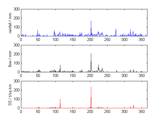
Several approaches of statistical modelling were applied, and indicated that the rainfall during the 1997/8 drought-year was (1) highly localised in space, even for regions dominated by convective rainfall, (2) strongly moderated by the local undulating topography, with marked seasonal (monsoon) changes, and (3) delivered primarily as regular, short duration events of low intensity rainfall. The visually classified patchwork of canopy types (supported by a series of biophysical measurements), showed significant differences in rates of wet-canopy evaporation. Smaller quantities of sub-canopy rainfall were observed beneath the disturbed patches of vegetation, in comparison to those beneath undisturbed remnants of primary rainforest. This may have been caused by (i) a greater rate of wet-canopy evaporation, due to enhanced atmospheric turbulence and/or higher surface leaf densities, or (ii) disturbed forest blocks receiving less gross rainfall, due to sheltering by the higher undisturbed canopies. Modelling of the 8-year post-logging water balance data, indicated that both seasonal and inter-annual cycles (related to the El Nino Southern Oscillation) strongly affected the rainfall (P), riverflow (Q) and 'P-Q' dynamics. On removal of these cyclical components, the analysis indicated that there was no evidence of a change in evapotranspiration (strictly 'P-Q') with the 8-years of forest regeneration.
Some of these results were unexpected, and underlined the need for a new emphasis on 'canopy hydrology' within rainforests managed for development and conservation.
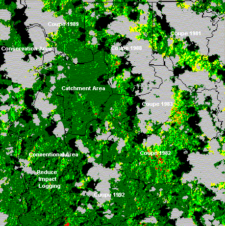
Classified 15x15 km sq. Landsat TM image of the Danum area
Dark green = climax forest, Light green = disturbed forest, Yellow = highly disturbed, now with pioneers,
Red = highly disturbed, now with ginger, Grey = cloud, Black = cloud shadow
Traditional forest inventory is time consuming, and it is difficult to know how many enumeration plots adequately characterise regional forest pattern, particularly with the complex vegetation mosaics associated with tropical, Selective Forestry Management (SFM). Remote sensing of those spectral properties correlated with inventory data, may offer a way to cheaply and more reliably interpolate patterns in key biophysical characteristics such as tree biomass (i.e., potential timber yield). This study, therefore, focused on a 15 x 15 km sq. Landsat TM image of a selectively managed forest (with a harvesting history over the period 1981 to 1993) in equatorial Borneo. Explanation of the spectral and biophysical characteristics of the region were attempted through a combination of helicopter-based radiometry (80 m sq.) and leaf-scale radiometry (80 cm sq.), together with a full enumeration of 50 plots, each 900 m sq..
Knowledge of the region allowed (supervised) classification of the image into classes of vegetation that comprised of: (a) areas of undisturbed, lowland dipterocarp forest, (b) disturbed areas containing commercial timber trees, and heavily damaged areas dominated by either (c) Macaranga spp. pioneers, and (d) ginger spp. These classes differed in their spectral characteristics, most notably in the near-infrared (NIR) waveband, which was low with virgin forest, and high in heavily damaged areas. Measurements of specific canopies from the helicopter platform, supported this finding, though leaf scale measurements were less conclusive due to their greater variability. Large, approximately 1,000-2,000 ha, blocks of forest could be similarly distinguished by their spectral characteristics. These differences, related to changes in the type of SFM practised, were supported by similar variations in tree basal area, standing timber volume and biomass derived from the plot enumeration. Indeed, the observations from the enumeration are important in their own right, given the dearth of such data for tropical SFM systems. Critically, a preliminary model correlating areally-integrated NIR monitored by Landsat TM with similarly integrated biomass data, resulted in a high degree of explanation (i.e., 76 % coefficient of determination).These findings lead me to conclude that there is great potential for interpolating traditional forest enumeration data with the aid of spectral characteristics, particularly those in near-infrared waveband. Such information should provide more accurate estimates of environmental status and potential timber production of natural rainforests managed by selective harvesting.
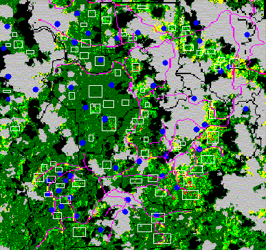
Classified 15x15 km sq. Landsat TM image of the Danum area
with enumeration plot location shown with blue dots, main haulage roads with pink lines
and white polgons are areas sampled for average radiance
Southeast Asia and the west Pacific experience the most intense large-scale convection on the planet. This convection is central to tropospheric circulations - such as the Hadley cell, the Walker circulation, and the inter-annual El Nino Southern Oscillation (ENSO) in the Walker circulation. The convection is also important in determining the tropical tropopause and, hence, the transport of water vapour and trace gases into the stratosphere. Lastly, the convection will act as an efficient pump, feeding short-lived chemical compounds into the upper tropical troposphere, where they may impact atmospheric chemistry on the regional scale.
The UK universities Global Atmospheric Modelling Programme (UGAMP) utilises the Meteorological Office 'Unified Model' (UM) for a wide variety of studies into climate and atmospheric chemistry. The UM is itself composed of several sub-models, including surface topography, a surface-processes model, and a parameterised convection scheme. This project will, first, assess the results of the modelled climate of SE Asia given the current model set-up - through comparison with measurements of convective cloud and rainfall time- series in particular. Lancaster's DHR-model, a new recursive interpolation, extrapolation and smoothing algorithm for non-stationary time-series, will be used to aid this comparison. The sensitivity of the UM to changes in the surface sub-models, in the light of hydro-climatic and land- use data collected in the region, will then be tested. Finally, the impact of large-scale, land-use change on the model climate will be studied, with particular emphasis on changes in rainfall regime and tropospheric convection.
The research will involve running the Meteorological Office 'Unified Model' on a supercomputer at Lancaster (or MCC) and fieldwork in Malaysia and/or Thailand to examine rainfall and land-use patterns (in association with the Royal Society Rainforest Research Programme).
The tropical climate, as captured by Global Climate Models (GCMs) is shown to be very sensitive to the loss of water and energy from the land-surface. As a result, changes in these losses due to tropical deforestation may be having regional or even wider climatic impacts. Some aspects of GCM performance have been, however, questioned in recent years. One area for concern is the representation of the land-surface hydrology within climate models, and organisations such as UK Meteorological Office are currently attempting to address this issue within their latest models. As part of the ongoing work to better link such hydrological and meteorological processes, this PhD studentship would focus on the hydro-meteorology of three 300 X 300 km2 regions in SE Asia - one in each of the following areas: Northwest Thailand (190 N), Central Peninsular Malaysia (40 N) and Northeast Borneo (40 N). These areas are selected as they cover a wide range of hydro-climatic conditions and contain experimental facilities for meteorological and hydrological research.
The PhD project involves the analysis of hydrology and meteorology of these three regions and a similar analysis of the results of the latest GCM simulations produced by the HadGEM model of the Hadley Centre (UK Meteorological Office). Lancaster's Data Based Mechanistic (DBM) analysis tools is used, and supplemented by fieldvisits to the research areas in Malaysia and Thailand. Collaboration with Dr Gill Martin of the Hadley Centre is central to the project, as is collaboration with meteorologists and hydrologists working in Malaysia and Thailand, and with other researchers in the UK Universities Global Atmospheric Modelling Programme (UGAMP).