Nick A. Chappell1, Paul McKenna1, Kawi Bidin1, Ian Douglas2 and Rory P.D. Walsh3
1Centre for Research on Environmental Systems and Statistics, IENS, Lancaster University, Lancaster LA1 4YQ, UK.
2Department of Geography, Manchester University, Manchester M13 9PL, UK.
3 Department of Geography, University of Wales, Swansea SA2 8PP, UK.
Email: n.chappell@lancaster.ac.uk
Modelling the impacts of complex distributions of sediment producing landforms on catchment-scale sediment behaviour requires an understanding of the role of (a) scale, and (b) new sediment-sources. This paper first examines the variations in sediment flux from 11 land-units ranging in size from the 0.1 ha 'landform-scale' to the 44 ha 'experimental-catchment'. Second, the work demonstrates the role of new sediment-sources with high sediment yields (sometimes triggered by extreme hydro-meteorological conditions) on behaviour at the landform to catchment scale. The analysis is based on 5-minute datalogged waterflow and suspended-sediment (calibrated turbidity) data from 11 weir and tipping-bucket gauging stations monitored over the period 1 July 1995 to 30 June 1996. Detailed work on sub-grid scale denudation and erodibility patterns was also undertaken. The study catchment is located within an area of tropical Borneo, where selective timber harvesting in 1988-89 left a mosaic of active erosional landforms including road gullies, eroding skid trails, mass movements and disturbed channel-heads.
Analysis of the time-series data indicated that the impact of localised road-culvert collapses and rotational landslides propagated through to the catchment-scale. Mass movements at new locations appeared part way through the time-series, giving rise to marked changes in the pattern of sediment flux within the catchment (compared to areas where gully or sheet-wash erosion dominated). This localised behaviour is likely to give rise to non-stationarity in sediment behaviour at the lumped catchment scale. Furthermore, not all of the mass movement events observed were related to extreme hydro-meteorological conditions and each had locally complex stability/erodibility patterns.
These conclusions lead the authors to investigate the value of transfer-functions (not requiring the definition of geomorphic parameters, such as stability/erodibility and topography) in identifying spatial and temporal patterns in suspended-sediment flux.
Current practices of 'selective' rainforest logging in Southeast Asia can generate high flows of suspended- sediment (Gupta, 1996). Semi-quantitative observations have suggested that the primary sediment sources giving rise to these high yields are, however, often localised to particular 'terrain elements', such as channel heads or skid trails (Douglas et al., 1995). The relationship between hydrological-erosional behaviour at this 'landform-scale' (Table 1) and that at the experimental catchment-scale has yet to be adequately described and modelled for this land system (Rose, 1993). The discretisation scale (or 'grid-scale') for parameterisation of distributed hydrological-erosional models is typically 100th to 1,000th of the catchment size, so for small experimental catchments of 10's ha the 'grid-scale' is approximately 0.1 ha which is within the range of the landform-scales within our study in Southeast Asia (Table 1).
The study that this paper forms a component part has attempted to describe and parameterise (i.e., model) the water and sediment flows at the grid- to catchment- scales. As the process descriptions are usually made at the 'point-scale' of perhaps less than 1 m2, identifying relationships between this integration unit and the grid and catchment units was also an objective. Numerous authors identify greater understanding of the relationship between point-, model grid- and catchment- scales as key to improvements in the modelling of hydrological (Blöschl and Sivapalan, 1995), erosional (Bathurst and Wicks, 1991; Rose, 1993) and climatic (Bruijnzeel, 1996) systems. Such developments would facilitate more robust model parameterisations, or the ability to estimate the behaviour of 'similar' catchments following limited measurement or with different feature distributions (e.g., primary sediment sources). A key element to this catchment modelling is an understanding of two characteristics of the hydrological-erosional system. These characteristics are: (i) the spatial variability in the suspended-sediment and associated water flux, and (ii) the changes in the relative importance of different sediment-sources over time, particularly following extreme events. This paper aims to address these two issues prior to forthcoming publications detailing the modelling work.
Multi-scale data collected for this research were monitored in rainforest terrain adjusting to forestry disturbance that occurred 5 years prior to the start of measurements. Identification of persistent and new sources of river suspended-sediments in terrain expected to be recovering from forestry operations was, therefore, the applied aim of the overall project. Indeed studies that describe the dominant hydrological-erosional processes operating at catchment-scales are increasingly demanded by those defining and assessing the criteria for sustainable forestry (Upton and Bass, 1996).
| Primary sediment source | area in plan (ha) |
|---|---|
| road-landslide | 0.25 (to 2+) |
| mass wasting at road culverts | 0.002 |
| road-gully | 0.02 |
| channel-head | 0.0005 |
| channel | continuum |
The research site was the 'Baru experimental catchment' located near to the Danum Valley Field Centre (DVFC) in Sabah, Malaysian Borneo (117o48.75' E, 5o01' N). This site was chosen for the study as (a) it had been monitored since 1988 prior to forestry operations, using a water-level recorder and an automatic-liquid-sampler or 'ALS' at a river section installed under a previous project (Douglas et al., 1992), and (b) its hydrological-erosional system was not thought to be atypical for Southeast Asia, given it comprises the most common soils for the region: acrisol-alisol (Chappell et al., submitted) and experienced a typical level of disturbance under a 'selective' (i.e., non-clearfelling) timber harvesting regime (Marsh and Greer, 1992).
The first stage of the project involved undertaking a detailed survey of active erosional landforms (i.e., road gullies, eroding skid trails, mass movements, active channel-heads) within the catchment, followed by a helicopter survey of the canopy disturbance. The grid-scale (ca. 0.1 ha) sites were then chosen to encompass the range of landforms observed (Tables 1 and 2). The surface contributory areas of these sites and the location of the permanent river channels were then added to the existing topographic map using compass-and-chain surveys in closed loop traverses. It was thought that upscaling would be more achievable if the water and suspended-sediment behaviour were monitored over a range of scales from the grid unit to the catchment unit. As a result, 8 grid-scale elements and 6 multi-grid scale elements (0.75 to 19 ha) were instrumented.
Where stations gauged regions expected to have high discharges (i.e., sites 1, 2-East, 2-Middle, 2-West, 3, 4, 5, and 6), 120o thin-plate V-notch weirs were constructed. All structures were built to a height of 1 to 2 m with zinc plate and concrete retaining walls and sites 1, 2-East, 2-Middle, 2-West were pinned into the solid bedrock. These structures were used, in preference to uncontrolled sections (after Douglas et al., 1992), to aid derivation of the discharge rating. Weir water-level was measured with Keller® pressure transmitters, and the standard discharge rating adjusted with a programme of current metering and salt dilution gauging. At channel-head and slope locations (i.e., sites 3TB, 4TA, 4TB, 5TA, 5TB, 6TA, 6TB), large locally-built tipping-bucket systems, individually calibrated, but ca. 3 litres, were constructed. At both types of gauging structure, Partech® IR15C turbidity probes were installed to measure suspended-sediment concentration continuously. In the case of the tipping-bucket structures, the turbidity probes were installed within the zinc approach flumes. This turbidity approach was chosen in preference to the use of 15 ALS, as (a) it reduced the risk of missing or under-representing data for extreme events (Kronvag et al., 1997), and (b) 5 minute resolution data was thought to be required for dynamic modelling, thus making the traditional filtration method unrealistic for so many sites. An intensive programme of spot water sampling for suspended-sediment was, however, undertaken at all sites to improve the calibration of the turbidity probes (after Clifford et al., 1995). Newlog® dataloggers with C-to-F and V-to-F converters were used to datalog pressure-transmitter and turbidity probe output that was subsequently calibrated to give instantaneous waterflow (cumecs) and suspended-sediment flux (kg s-1). Six tipping-bucket raingauges were also installed across the catchment (and a further 4 outside the catchment), and datalogged with the same systems. Gauges at sites 1, 3, 4 and 6 were placed on ironwood towers up to 6 m in height to prevent attack from wild boar or cover by regenerating vegetation, while the exposed site 5 gauge was located within a 2 m high and 5 m diameter chert/concrete wall to prevent elephant attack.
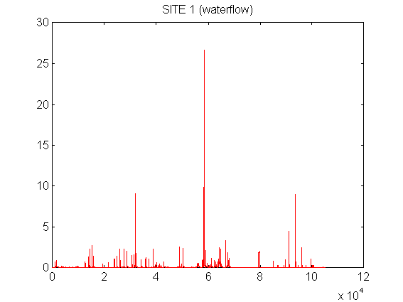
Data concatenation, rating and subsequent analysis was undertaken by the using the MATLAB® programming environment. Of the 15 gauging stations installed, four stations produced only limited records - site 6 was destroyed one day after installation (4-Dec94) by a road-landslide, while site 3, 4TB and 6TB logging systems were damaged by electrical storms. The core analysis was, therefore, undertaken on 5-minute data (105,120 values per variable) measured at 11 sites: 1 lumped catchment unit, 5 grid-scale, and 5 multi-grid scale units over the 12 month period 1 July 1995 to 30 June 1996 (e.g., Figure 1).
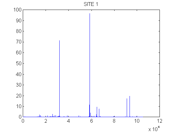
Figure 1. Example traces of 5 min data for 1/7/95-30/6/96 for (a) instantaneous discharge at site 1 (cumecs km-2), and (b) instantaneous SS-flux at site 1 (kg s-1 km-2).
Interpretation of the suspended-sediment flux (SS-flux) from catchment scale terrain units is usually explained by semi-quantitative observations (i.e., quantitative but not statistically robust sampling) at the 'point-scale' (see e.g., Rose, 1993; Douglas et al., 1995). Very small-scale measurements of erosion were, therefore, made twice per year at clusters of erosion pins and erosion bridges within the channels at sites 2-East, 2-Middle, 2-West, 3, 4, 5TB, and 6TB, and also on the undisturbed slope of site 3TB (see Walsh and Bidin, 1995). Further, a preliminary assessment of the soil erodibility at eroding and non-eroding landforms was undertaken to help in the interpretation of the observed grid-scale suspended sediment flux. Soil sensitivity to local erosion was characterised with soil aggregate stability (by rainfall simulation) tests (Ternan et al., 1996). Bulk soil physical and chemical properties, including organic carbon, clay content, exchangeable sodium percentage and clay mineralogy, were also measured on the same 21 sampling locations as the aggregate stability, to afford an explanation of the differences in stability (Chappell et al., submitted).
The arithmetic-mean rainfall received by the 6 catchment gauges from the 1 July 1995 to 30 June 1996 was 2,956 mm with a modest spatial coefficient of variation (CV) of 10.1 per cent. This indicates a slightly wetter period in comparison to the 11 year (1986-1996) mean of 2,778 mm yr-1 (( 312 mm SD or 11.5 per cent temporal CV) for the nearby DVFC gauge. The waterflow passing through the site 1 gauge was 1,867.1 mm, indicating a runoff coefficient of 63 per cent. The runoff coefficients for the slightly smaller sites 2-Middle and 2-West fell to 57 and 54 per cent respectively, while sites 2-East, 4 and 5 generated only 30, 39 and 6 per cent respectively, indicating an increasing loss of site waters by subsurface pathways as surface-contributing-area decreases (see Bidin, 1995). The very small runoff coefficients for sites 3TB, 4TA, 5TA and 5TB of 1.0, 2.0, 2.0 and 1.9 per cent respectively, probably relate to infiltration-excess overland flow rather than the dominant subsurface flow observed at larger scales. Such a small proportion of Hortonian overland flow from all sites except very indurated surfaces (e.g., the haulage road contributing to site 6TA) is expected (see Sinun et al., 1992; Sherlock, 1997). The smaller runoff coefficients for our grid-scale units are, therefore, expected to give a smaller suspended sediment flux (i.e., waterflow x suspended sediment concentration) per unit area.
The total SS-flux from the Baru catchment (site 1) over the 1 July 1995 to 30 June 1996 period was 592 tonnes km-2 yr-1. This flux is considerably lower than that monitored for the site over the logging and immediate post-logging period (1-Jun88 to 31-Aug90) of 1,600 tonnes km-2 yr-1 (Douglas et al., 1992). For reference, the yield of an undisturbed catchment (2 km away) was 312 tonnes km--2 yr-1 over that period (op. cit.). Over the 1 July 1995 - 30 June 1996 period, the 5 multi-grid sites generated between 14 and 1,467 tonnes km-2 yr-1 with a spatial CV of 85 per cent (Table 2). Our 5 grid-scale fluxes ranged from only 15 to 99 tonnes km-2 yr-1 with a spatial CV of 70 per cent (Table 2). Clearly, our limited grid-scale sites of un-logged slopes (site 3TB), ephemeral channels (sites 5TA, 5TB), poorly indurated skid trails (site 4TA) and haulage road drain overflow (site 6TA) does not indicate that they are the dominant source of sediments observed at the lumped catchment unit. In contrast, the catchment-lumped response lies within the variability observed at the scale of multi-grid regions. Some assurance of the reliability of the data (see Kondolf and Matthews, 1991) is gained from the observation that the multi-grid regions of 2-East, 2-Middle and 2-West (that comprise 86 per cent of the Baru catchment and probably most of the primary sources), yield only 10 per cent less annual sediment flux (i.e., 234 tonnes) in comparison to that recorded at the site 1 gauge (i.e., 261 tonnes). Site 2-West generated relatively modest SS-flux in comparison to the other two site 2 regions, despite including the highest degree of canopy disturbance and site 4 (occupying 7 per cent of the 2-West area) - the severely gullied haul road with 643 tonnes km-2 yr-1 SS-flux. The 4.6 ha site 2-East generated a high SS-flux per unit area as result of a combination of re-mobilisation of sediment from a 0.3 ha road-landslide that occurred on the 4-Dec94 (that buried structure 6), and a new adjacent 0.2 ha road-landslide that occurred on the 19-Jan96 (see next Section). This site did in fact contribute 39 per cent of the suspended sediment mass passing station 1 while occupying only 10.4 per cent of Baru catchment area. Site 2-Middle generated a slightly higher SS-flux (685 tonnes km-2 yr-1) than the lumped catchment response, and qualitative field observations (supported by analysis in the next section) indicated that this site was strongly influenced by soil collapse at two road culverts during the storm of 19-Jan96 (see Figure 3).
| A: site | B: area (km2) | C: scale | D: runoff (mm) | E: SS-flux (t/km2/yr) | F: SS-flux (tonnes) | G: F(x)/F(1) (%) | H: SS-flux on 19Jan96 (tonnes) | I: H(x)/F(x) (%) |
|---|---|---|---|---|---|---|---|---|
| 1 | 0.441 | catchment | 1867 | 592 | 261 | 100 | 105 | 40.3 |
| 2-East | 0.046 | multi-grid | 908 | 1467 | 67 | 39 | 33 | 49.2 |
| 2-Middle | 0.143 | multi-grid | 1684 | 685 | 98 | 36 | 40 | 41.0 |
| 2-West | 0.190 | multi-grid | 1611 | 361 | 69 | 26 | 11 | 15.6 |
| 4 | 0.013 | multi-grid | 1162 | 643 | 8.4 | 3 | 1.1 | 12.8 |
| 5 | 0.0075 | multi-grid | 187 | 14 | 0.107 | 0.04 | 0.012 | 11.5 |
| 3TB 1 | 0.0006 | grid | 31 | 24 | 0.015 | - | - | - |
| 4TA 1 | 0.00155 | grid | 60 | 81 | 0.126 | - | - | - |
| 5TA 1 | 0.00145 | grid | 60 | 15 | 0.022 | - | - | - |
| 5TB | 0.0014 | grid | 57 | 41 | 0.058 | 0.02 | 0.020 | 34.1 |
| 6TA 2 | 0.0003 | grid | 78 | 99 | 0.030 | 0.01 | 0.010 | 31.1 |
On 19-Jan96 a rainstorm, with the highest daily rainfall on record at DVFC (1986-1996) of 167 mm, generated very high water and suspended sediment flows from the Baru catchment. Some 105 tonnes or 40.3 per cent of the annual SS-flux from the catchment was generated (Table 2). The importance of such extreme events to sediment load has been noted by previous studies undertaken at this (Douglas et al., 1992) and other sites (e.g., Webb and Walling, 1982) and underlines the importance of continuous rather than spot sampling that might inadequately characterise these events. The presence of these short periods of high SS-flux within the records does not, however, necessarily imply that the hydrological-erosional system is either non-linear (where parameters, i.e., 'characteristics of modelled behaviour', of a linear model, change with storm size) or non-stationary (where the form of the relationship between the rainfall and SS-flux changes even with the same storm size) (Young, 1984). The activation of new primary sediment sources within the catchment, as a result of, for example, slope failure may, however, enhance non-linearity or even add non-stationarity. By subtracting the lumped catchment (site 1) SS-flux from the 5-min time-series data for all other sites, (a) the activation of major new sediment sources, (b) the location of those new sources and (c) re-mobilisation of sediments from major sediment sources can be seen. For example, the first large positive peak (21-Oct95) in Figure 2 relates to re-mobilisation of sediments from the 4-Dec94 landslide in site 2-East (either from the landslide-foot or from in-channel storage) during highflow conditions, while the second positive peak relates to the new road-landslide triggered on 19-Jan96, and the last (smaller) positive peak relates to re-mobilisation of sediments from the 19-Jan96 landslide.
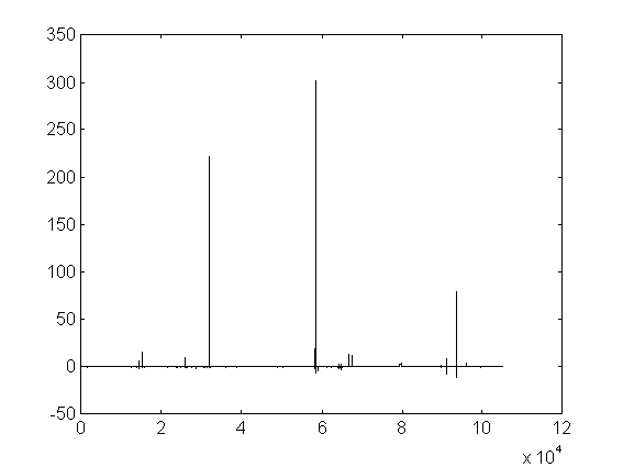
Figure 2. Instantaneous SS-flux (kg s-1 km-2) in 5 min period at gauging station 1 subtracted from that at station 2-East
In contrast, the other important source: site 2-Middle, generated a positive anomaly related to the failure of two road culverts during the extreme rainfall of 19-Jan96, though an anomaly was not observed on the 21-Oct95 as site 2-Middle lacked sediments for re-mobilisation (Figure 3).
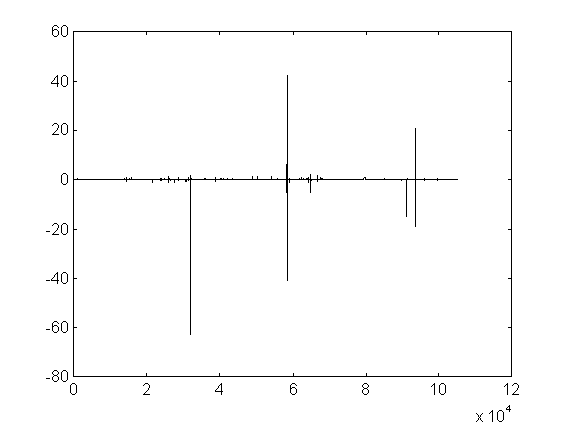
Figure 3. Instantaneous SS-flux (kg s-1 km-2) in 5 min period at gauging station 1 subtracted from that at stattion 2-Middle
Examination of the data for site 4: the road-gully, demonstrates that while some of the greatest 5-min SS-flux was generated during the 19-Jan96 event, the anomaly was negative (Figure 4), indicating that the lumped site 1 contained new sources while site 4 did not. The greater proportion of the annual SS-yield at sites 2-East and 2-Middle generated during the 19-Jan96 event (i.e., 49.2 and 41 per cent respectively) in comparison to, for example, site 2-West (15.6 per cent) also supports the idea of new sources being activated. Given the large impact of new sediment sources (due to mass wasting) in certain terrain elements on changes to lumped catchment behaviour (at least during extreme events) the hydrological-erosional system might be expected to show non-stationarity. Predicting the location of these new sediment sources is clearly important in understanding how larger-scale (i.e., catchment) SS-flux may change.
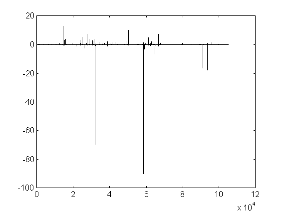
Figure 4. Instantaneous SS-flux (kg s-1 km-2) in 5 min period at gauging station 1 subtracted from that at station 4
Examination of point measurements in the erodibility measure of aggregate stability (and related factors) at the 4-Dec94 landslide headwall (site 2-East), an indurated skid trail, channel-headwall and undisturbed, planar slopes indicated that soil instability was localised in specific soil horizons (Chappell et al., submitted). The cut-and-fill material comprising the haul road, that failed by landsliding (site 2-East) and culvert collapse (site 2-Middle) had by far the most unstable strata, though the instability at the landslide site was particularly localised to an active percoline. While the skid trail soils showed some instability, pockets of very unstable soils were observed within the natural channel-head soils (Chappell et al., submitted). Catchment-scale paramterisation of such localised soil instability (perhaps of equal significance as local slope or contributing-area factors) for a physically-based model may, therefore, require 1,000's or 10,000's of soil stability measurements which is clearly a major limitation (Bathurst and Wicks, 1991; Rose, 1993; Lřrup and Styczen, 1996). Moreover, as the 4-Dec94 landslide occurred after only 15.2 mm of rainfall within a relatively lowflow period, even with such data, prediction may remain highly uncertain.
Primary mobilisation of sediments from channel banks and the re-mobilisation of deposited sediments (e.g., temporary in-channel storage of landslide materials) takes place over a continuum of scales (Table 1; Bak, 1997) and is, therefore, difficult to characterise with fixed grid-scale units. Point-scale, erosion bridge measurements at various channel cross-sections do, however, illustrate the role of changing channel storage in the behaviour of the grid- to catchment- scale integration regions, in particular, following the activation of new sources (Walsh and Bidin, 1995). For example, a single erosion bridge site across the lower channel of site 2-East shows that the 19-Jan96 landslide caused channel storage to increase immediately following the event (Feb96 survey) which continued to increase to the survey of Aug96, therefore, explaining the positive anomaly in 'site 2-East minus site 1 SS-flux' later within the year (Figure 2). Much of this temporary storage of landslide sediments was then depleted by the Mar97 survey.
1. In comparison to the multi-grid scale (0.75 to 19 ha) and catchment scale (44 ha) terrain areas, the smaller grid or landform scale (0.1 ha) areas studied, generated significantly less suspended-sediment. The lack of permanent (surface) runoff within these smaller areas as compared with the larger areas (with their perennial channels) may, in part, explain the reduced sediment delivery observed. Clearly, catchment modelling that inadequately parameterises the sediment generation (and loss) within channel and near-channel areas would underestimate catchment-scale fluxes.
2. Suspended-sediment mobilised during extreme events can make a very significant contribution to the annual flux of suspended-sediment from regions the size of experimental-catchments and smaller. Where extreme events generate new sediment sources (both primary and secondary), then these are locally important during these events and in subsequent smaller storm events. Of equal emphasis, however, is the observation that very visible, large landslides, may be less important to the annual suspended-sediment flux than smaller but more numerous sources such as the road-culvert collapses observed within site 2-Middle. This reinforces the idea that modelling, not only needs to be able to simulate the behaviour of these dominant (in terms of SS-flux) sources, but also needs sound field evidence of the role of localised sources at the larger catchment-scale, for validation.
3. The preliminary soil analyses indicate that some primary sediment sources generate high suspended-sediment flows as a result of highly localised intra-landform instability in the soils. Indeed if landslides are present, this instability may develop over time. Modelling, therefore, needs to be able to cope with the appearance of new sources within the catchment and perhaps without a soil property-based understanding of the exact location of potential new sources. These two conclusions have lead the authors to apply transfer-function (TF) models (e.g., Young, 1984; Young and Beven, 1994) to the multi-scale Baru catchment data.
4. The work has also raised applied issues. Those multi-grid elements that have high SS-flux (and grid elements impacting at this larger-scale) are seen to contain mass movements along road-corridors either as collapse of road culverts (which are hollow logs) or landslides. The role of skid trails (i.e., the tracks made in the process of taking timber to the lorry haulage roads) and gully erosion (at channel heads or along roads or skid trails) seems less important. As current reduced-impact, selective forestry criteria focus on protecting skid trails from surficial erosion (Upton and Bass, 1996) rather than haul roads from mass wasting, perhaps greater soil-conservation benefits would be obtained by prioritising the protection of haul roads (certainly within similar regions of acrisol-alisol soils). This conclusion supports the earlier work of Megahan and Kidd (1972), Krag et al., (1986), Coker et al. (1990) and Larsen and Parks (1997). Furthermore, given that new mass movements occur several years after logging activity, assessment of forestry systems for sustainability certification needs to be undertaken following at least 5 years of post-logging monitoring as suggested by Chatwin and Smith (1992).
Bathurst, J.C., and Wicks, J.M. 1991. Framework for erosion and sediment yield modelling, in D.S. Bowles and P.E. O'Connell (eds) Recent Advances in the Modeling of Hydrologic Systems, Kluwer, 269-288.
Beven, K. 1997. Distributed Hydrological Modelling: Applications of the TOPMODEL Concept, Wiley, Chichester.
Bidin, K., 1995. Subsurface flow controls of runoff in a Bornean natural rainforest, Unpublished MSc thesis, University of Manchester, pp128.
Blöschl, G., and Sivapalan, M. 1995. Scale issues in hydrological modelling: a review, in J.D. Kalma and M Sivapala, (eds) Scale Issues in Hydrological Modelling, Wiley, 9-48.
Bruijnzeel, L.A., 1996. Predicting the hydrologicl impacts of land cover transformation in the humid tropics: the need for integrated research, in J.H.C. Gash, C.A. Nobre, J.M. Roberts, and R.L. Victoria (eds) Amazonian Deforestation and Climate, Institute of Hydrology and Wiley, 15-55.
Chappell, N.A., and Ternan, J.L., 1992. Flow-path dimensionality and hydrological modelling, Hydrological Processes, 6, 327-345.
Chappell, N.A., and Ternan, J.L., 1997. Ring permeametry: design, operation and error analysis. Earth Surf. Processes and Landforms, 22, 1197-1205.
Chappell, N.A., Franks, S.W., and Larenus, J. 1998. Multi-scale permeability estimation for a tropical catchment, Hydrological processes, 9.
Chatwin, S.C. and Smith, R.B., 1992. Reducing soil erosion associated with forestry operations through integrated research: an example form coastal British Columbia, Canada, in Erosion, Debris Flows and Environment in Mountain Regions, IAHS Publ. 209, 377-385.
Clifford, N.J., Richards, K.S., Brown, R.A., and Lane, S.N., 1995. Laboratory and field assessment of an infrared turbidity probe and its response to particle size and variation in suspended sediment concentration. Hydrol. Sci. Jnl., 40, 771-791.
Coker, R.J., Pearce, A.J., and Fahey, B.D., 1990. Prediction and prevention of forest landing failures in high intensity rainfall areas of northern New Zealand, , in Research Needs and Applications to Reduce Erosion and Sedimentation in Tropical Steeplands, IAHS Publ. 192., 311-317.
DeBoer, D.H., and Crosby, G. 1996. Specific sediment yield and drainage basin scale, in Erosion and Sediment Yield: Global and Regional Perspectives, IAHS Publ. 236, 333-338.
DeRoo, A.P.J. 1993. Modelling Surface Runoff and Soil Erosion in Catchments with Geographical Information Systems, Universiteit Utracht, pp295
Douglas, I., Spencer, T., Greer, T., Bidin, K., Sinun, W. and Wong, W.M., 1992. The impact of selective commercial logging on stream hydrology, chemistry and sediment loads in the Ulu Segama Rain Forest, Sabah, Phil. Trans. Roy. Soc. Lond. B, 335, 397-406.
Douglas, I., Greer, T., Sinun, W., Anderton, S., Bidin, K., Spilsbury, M., Suhaimi, J., and Sulaiman, A. 1995. Geomorphology and rainforest logging, in D.F.M. McGregor, and D.A. Thompson, D.A. (eds) Geomorphology and Land Management in a Changing Environment, Wiley, 309-320.
Freeze, R.A. 1972. The role of subsurface flow in generating surface runoff 2. Upstream source areas. Water Resour. Res., 8, 1272-1283.
Gupta, A. 1996. Erosion and sediment yields in Southeast Asia: a regional perspective, in Erosion and Sediment Yield: Global and Regional Perspectives, IAHS Publ. 236, 215-222.
Kondolf, G.M., and Matthews, W.V.G. 1991. Unmeasured residuals in sediment budgets: a cautionary note. Water Resour. Res., 27, 2483-2486.
Krag, R.K., Sauder, E.A., and Wellburn, G.V., 1986. A forest engineering analysis of landslides in logged areas on the Queen Charlotte Islands, British Columbia. Land Management Report 43, BC Ministry of Forests, Victoria, BC, Canada.
Kronvang, B., Laubel, A., and Grant, R. 1997. Suspended sediment and particulate phosphorus transport and deliver pathways in an arable catchment, Gelbćk strem, Denmark, Hydrological Processes, 11, 627-642.
Larsen, M.C. and Parks, J.E. 1997. How wide is a road ? The association of roads and mass-wasting in a forested montane environment, Earth Surf. Processes and Landforms, 22, 835-848.
Lřrup, J.K. and Styczen, M. 1996. Soil erosion modelling, in A.B. Abbott and J.C. Refsgaard, (eds) Distributed Hydrological Modelling, Kluwer, 93-120.
Marsh, C.W. and Greer, T. 1992. Forest land-use in Sabah, Malaysia: an introduction to Danum Valley, Phil. Trans. Roy. Soc. Lond. B, 355, 331-339.
Megahan, W.F., and Kidd, W.J. 1972. Effects of logging road on sediment production rates in the Idaho batholith. USDA For. Serv. Res. Pap. INT-123.
Rose, C.W. 1993. Erosion and Sedimentation, in Bonell, M., Hufschmidt, M.M., and Gladwell, J.S., (eds) Hydrology and Water Management in the Humid Tropics, Cambridge University Press, 301-343.
Sherlock, M.D., 1997. Plot scale hydromertic and tracer characterisation of soil water flow in two tropical rain forest catchments in South-east Asia, Unpublised PhD thesis, Lancaster University, pp352.
Sinun, W., Wong, W.M., Douglas, I., and Spencer, T. 1992. Throughfall, stemflow, overland flow and trhoughflow in the Ulu Segama rain forest, Sabah, Phil. Trans. Roy. Soc. Lond. B, 355, 389-395.
Ternan, J.L. Williams, A.G., Elmes, A., and Hartley, R. 1996. Aggregate stability of soils in central Spain and the role of land management. Earth Surface Processes and Landforms, 21, 181-193.
Upton, C. and Bass, S. 1996. Forest Certification Handbook, St Lucie Press, Boca Raton, pp176.
Walsh, R.P.D., and Bidin, K. 1995 Channel head erosion in primary and logged rain forest in Sabah, in Abstracts of the Internat. Assoc. Geomorphologists, Southeast Asia Conference, Singapore, 18-23 June 1995, 79.
Webb, B.W. and Walling, D.E., 1982. The magnitude and grequency characteristics of fluvial transport in a Devon drainage basin and some geomorphological implications. Catena, 9, 9-23.
Young, P.C. 1984. Recursive Estimation and Time Series Analysis, Springer, Berlin.
Young, P.C. and Beven, K. 1994. Data-based mechanistic modelling and the rainfall-flow non-linearity, Environmetrics, 5, 335-363.